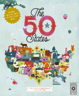
The 50 States
Explore the U.S.A. with 50 fact-filled maps!
This title was previously available on NetGalley and is now archived.
Send NetGalley books directly to your Kindle or Kindle app
1
To read on a Kindle or Kindle app, please add kindle@netgalley.com as an approved email address to receive files in your Amazon account. Click here for step-by-step instructions.
2
Also find your Kindle email address within your Amazon account, and enter it here.
Pub Date May 7 2024 | Archive Date Jul 19 2024
Quarto Publishing Group – Wide Eyed Editions | Wide Eyed Editions
Talking about this book? Use #The50States #NetGalley. More hashtag tips!
Description
Discover more than 2,000 facts about the people, cities, nature and historic events that have helped make America what it is today. Ghost towns, swamp tours, the center of the universe… bacon donuts, brainy berries, salmon jerky… The French Fry King, The Mother of Oregon, The Queen of Blues… be inspired by the inventiveness, beauty and diversity of our great nation in this curious collection of fact-filled maps.
On each weird and wonderful map, find:
- A welcome box with a short introduction to the state
- Key facts, including the capital; state bird, flower and tree; and statehood order
- State icons celebrating the state’s people, places and history
- Six inspiring people who have a connection to the state
- Region spotlight bubbles to allow you to discover more about one particular place
- A moments to remember box with a list of significant dates and their events in the state’s history
Each state’s map also contains information about which states it neighbors, its bodies of water and borders as well as where it is situated in the country. Did you know that while Hawaii shares its border with no one, both Missouri and Tennessee border eight other states? Many state parks, battlefields, national forests and reservations are also included to inspire you to explore the great outdoors.
So pack your bags and say later ‘gator… the great States await! The 50 States series of books for young explorers celebrates the USA and the wider world with key facts and fun activities about the people, history and natural environments that make each location within them uniquely wonderful. Beautiful illustrations, maps and infographics bring the places to colorful life.
Also available in this series:50 Adventures in the 50 States, 50 Trailblazers of the 50 States, Only in America, Only in California, Only in Texas, We Are the United States, and a wide range of activity books.
Available Editions
| EDITION | Other Format |
| ISBN | 9780711291775 |
| PRICE | $14.99 (USD) |
| PAGES | 112 |
Available on NetGalley
Average rating from 59 members
Featured Reviews
I’m a sucker for geography as I studied Tourism years ago. I love facts and history about places and have an obsession for the USA. It is one of my favorite holiday destinations. So it was great to read and learn more about all the places I can visit in the future.
What a great book to teach not only children, but also people of all ages about the USA. I loved that the book was in alphabetical order. Each page was so fun to look at and offered informative graphics and great pieces of information ad history and fact. Very well done book.
 Megan I, Reviewer
Thank you so much to NetGalley and Quarto Publishing for my copy of The 50 States by Gabrielle Balkan in exchange for an honest review. It publishes May 7, 2024.
This was such a fun and informative book! As a homeschool mom who loves to travel, and is raising little travel-lovers, this is the perfect book for my family! But even if you don’t love to travel, I think this would be a great fit for any kid, library, or classroom!
This has so much packed into it. Probably one of the coolest books I’ve seen on the fifty states and the most facts I’ve seen on the states. I was really excited for my kids to read this. They’re finally learning about the states and this book was so colorful and engaging. The fact’s ranged from fun random facts to some cool historical facts. My favorite was learning the origin of each states name. I would definitely recommend this book to family and friends and anyone with school aged kids. This was awesome!
I voluntarily reviewed this after receiving a copy.
 Reviewer 409992
Thank you to NetGalley and the publisher for providing me with this book in exchange for my review! All opinions are my own.
As someone who is fascinated with history, I enjoyed this children's book, I thought the illustrations were colorful and eye-catching. I would say that this book would probably be best suited for children 7+, -- I think it may be a little advanced for some readers. But the great thing about this book is that it both entertains AND educates children. This book is the perfect book for elementary school teachers and librarians to add to their shelves. I enjoyed reading this book overall :)
Connect with Me <3
My blog is https://bookreviewsbyjules.blogspot.com/
Goodreads: https://www.goodreads.com/user/show/44083250-julia
Instagram/bookstagram: https://www.instagram.com/bookreviewsbyjules/
Substack: https://bookreviewsbyjules.substack.com/
This book offers a captivating journey through America's diverse landscape, providing readers with a comprehensive collection of fascinating facts about each state. From the historical landmarks to unique tidbits of information, the book expertly weaves together an engaging tapestry of information. I love the layout of the book. As a homeschool parent, this will be a fantastic resource!
Thank you for the opportunity to read and review this book!
The 50 states is a children's nonfiction book about all of the states in the USA. Each state has a bunch of different facts and pictures to go along with the facts.
This book was really nice! It has great information and really nice illustrations. It has a ton of information about the different states. It was interesting to read about the different states. I think kids will really enjoy reading this book and looking at the pictures. The pictures are all colorful and vibrant. I really liked the font choices as well. Everything looked nice on the page.
Thanks so much to netgalley and Quarto Publishing Group – Wide Eyed Editions, Wide Eyed Editions for the arc of this book in exchange for an honest review.
Jessica R, Reviewer
Beautifully done. So much info on each states, with such a variety of events and people in and from each of the states that students will find something that they enjoy about each state. It was a little overwhelming and overstimulating for my kids. Maybe in book form would have been easier for them to read instead of this digital form. But aesthetically, this book is a 10/10 for me!
The 50 States book is both beautiful and educational. I loved that each page was so eye catching and packed full of different facts about each state. I’m young son is really into the United States right now. So this was a perfect book to help him increase his knowledge in a fun and engaging way. I highly recommend this book for people who are trying to increase their children’s love and knowledge of the states.
This book is so fun and absolutely gorgeous. I’ve been obsessed with America since having a jigsaw puzzle as a child that taught me all of the names of the states. I’ve remembered every state and am now passing on a similar obsession to my son.
The pictures are so lovely - rich and vibrant colours that are a treat for the eyes, and each page is dense with interesting facts and ‘wow, i didn’t know that’ moments.
I can’t wait to be able to purchase this in hard back so that we can paw over it regularly and I can help my kids memorise the states too!
This was a very interesting read for me as it provided me with lots of new information of different states in America.
I have three kids and they all loooove to read. The problem that I sometimes find is that their books lose favor with them quickly, especially as they grow into independent readers. This book is the exception -- you can buy it (maybe even grab one for each kid because they won't want to share) and your children will find something new every time they open the book. The pictures are so beautiful, the facts are interesting, and my kids are learning about US History. It's a win-win.
I'll give an example from my home state of Maine:
- Gorgeous font and photos that kids and adults will enjoy
- There is a map showing where the state is in relation to the rest of the country
- It gives "moments to remember" which include, aptly, the launch of LL Bean
- Key facts give quick facts like the statehood date, the state flower (white pine cone!) and the capital
- The map itself, the centerpiece, reads like an infographic which highlights famous Mainers and highlights some of the natural sights of the state, including my personal favorite, Katahdin
Beautiful book that I'm going to buy for all my friends kids when their birthdays roll around.
Reviewer 1297876
I’ve been eyeing this book for awhile and jumped at the chance to review it!
As a homeschool mom- this book is everything I could dream it would be. We loved the fun, interesting facts. Aesthetically, it was pleasing to look at (and yes- would look great on a shelf!). My kids are studying American history this year, and I think it would be a great resource to use for research projects or even just learning a couple states a week. I have a daughter that is obsessed with the states right now and is loving learning all the new things that aren’t in every other state book we own. This one is unique and different and would be a great addition to a homeschool shelf (or even a classroom shelf or child’s book shelf- every kid needs access to this book!).
Thanks NetGalley for the chance to review this book. I was provided an electronic copy for review, but all views and opinions are my own.
Educator 1292066
Absolutely love this book! We own the previous edition, and it is staple in our homeschool library. We use it daily for our geography lessons. My children love the bright colors and artwork. The facts included have helped to encourage them to seek further information on the topics discussed and the states. I will be recommending it to others and purchasing it for our home once it is released.
Thank you NetGalley and Quarto Publishing Group - Wide Eyed Editions for the ARC to review!
This is an amazing and adorable collection of the 50 states. I really liked the lay out and infographics, lots of great information to introduce you to the states. Definitely one we will add to our library.
Emilie P, Reviewer
Thank you Netgalley and the publisher for this arc.
I'm a travel girlie and this kind of books makes me so happy. It's a great addition to my collection of travel books. I loved the map at the beginning of the book with all the names and all the little illustrations. The information of each state was very clear and easy to understand/read for someone whose first language isn't English. I recommend this book to all the travel lovers! It's also a great gift to give to someone. I'll read this book over and over again and I will definitely buy this one <3
Robin F, Librarian
Love an informational book about the United States that children can read and understand. I wish this book was around when I was a kid. I will definitely be requesting this book be added to our circulation at the library!
I really like the illustrations that show the major elements and facts about each states in the USA. I like the creativity and the colors - infographics just make my artist heart glad! Even as an adult, I feel tempted to buy a hard copy of this for myself.
A lot of research go into a book like this. I feel confident about the accuracy of the facts as librarians and fact-checkers were used, and for just one country. For a book about the whole world, I think it would have been more difficult.
5 stars.
Reviewer 937774
This is a great book for young kids to learn about the 50 states and the US capitol. Each state is featured with a blurb about the state and highlights famous people from the state, important events that occurred in state history, fun facts about the state, popular sites, info about various cities throughout the state, and more.
The illustrations are cute and engaging. A great companion for children that are learning about US geography and the 50 states.
Hayley G, Reviewer
This is a lovely educational book. Beautifully illustrated and jam packed full of interesting facts and trivia about each State, covering a wide range of things. Each State is given its own two pages in the book. The only thing I would say is we had this as an ebook, to fully appreciate the book I feel it would be better read in physical format especially as each page is so jam packed with information.
Rakhee M, Reviewer
Thank you NetGalley for providing me with an ARC of this book in exchange for an honest review. This book is so fun, and informative. It was enjoyed thorowly by me and my kids. The only draw back was the format i recieved, could not read it on kindle or any other tablet. Had to read it on laptop which was not convininet at all. But it is a beautiful book and would buy the phisical copy to enjoy.
Reviewer 1342435
"The 50 States" by Gabrielle Balkan is a visually stunning book full of infographic maps of the United States.
I appreciated the inside cover page that explains how to explore the book. Packed full of facts about famous people, state icons, largest cities, places of interest, and more, this book would make the perfect classroom companion for public schools, private schools, and homeschools alike.
I can't get over the graphic design of this book. It's absolutely brilliant! The illustrations are colorful; the fonts are fun, yet readable; and the infographics are well laid-out. Children of all ages will be drawn to this book, and parents and teachers will love reading it to them!
I received an advance copy of this book from NetGalley in exchange for an honest review.
Librarian 1043995
I'm not super up on what's going on with fact-filled browsable books like this, but this is a fun and engaging one. I can imagine the right kid getting obsessed with devouring all the fun facts, and more casual readers spending plenty of time on their own (and neighboring) states.
5/5 Stars!!!
I LOVE this book! The illustrations are whimsical and eye catching. Each state really gives a good representation of what makes it well known, influential people, and fun facts as well as giving you the typical stats you would find in a geography book. I am from the state of Oregon and can say for certain that all information is true from our state flower, the Oregon grape, to Voodoo Doughnuts! I was thoroughly impressed by the amount of research completed to make this book as comprehensive as it is.
I would recommend this book to anyone looking for specific state history or just wants to learn about the 50 states.
Thank you to NetGalley and Quarto Publishing for the arc of this book in exchange for my honest review.
Carla P, Reviewer
The 50 States is a great to use as part of your homeschool curriculum, to plan a family vacation, or just for fun. It has key facts, information about famous people who have called each state home, fun art and so much more! Read it straight through or pick and choose which state you want to learn about each day! You can keep going back to it over and over!
Erin S, Librarian
This book is full of fun facts about each of the 50 United States! Each page includes fun facts, interesting places, famous people, as well as basic information such as order and date of statehood, state flower, and more. The colorful graphics add visual interest too. This is a great book for young readers who want a fun overview of the 50 states.
The illustrations in this book are super cute and so colorful. It has a great mix of information from places of interest to important historical figures from each state. It's informative and educational while still being fun.
Jam packed with facts and colourful illustrations this is a great book for children to learn about each of the 50 states. Each states is listed in alphabetical order with its own page filled with famous people, key facts, state icons, places of interest and more.
This is a book to come back to again and again.
Librarian 1372649
Beautiful, colorful illustrations and lots of information for little readers. We will add this to our library in May
Vicky Z, Educator
This book has a double spread lay out for each state with the main cities identified on the map. There is key information, famous people, and moments to remember highlighted for each state. There is a lot of information on each spread, but it is very engaging and organized rather than being overwhelming.
Educator 985113
I received a complimentary copy of this book via Netgalley. Opinions expressed in this review are my own
I enjoy educational books like The 5o States. The mix of fun trivia and important facts make reading fun. The pages are bright, and the illustrations really help one take in the information given on each page.
Educator 987175
Thanks to the publisher and NetGalley for letting med review this book. This was a fun read about the various states and fun facts. I like that there were several kids’ book recommendations as well.
The 50 States is a wonderful educational tool for children. Filled to the brim with historical data, facts about each state, and other tidbits of information, children of all ages will find this book informative. The colorful and vibrancy of the illustrations grab your attention.
I loved the historical facts, state information, and the spotlights on famous and influential people who came from each particular state. The "Moments to Remember" included on each page feature historical events and the dates they occurred. I enjoyed learning different things about each state, but especially my own state of Michigan. This a great tool for educating everyone about the United States.
Lana A, Reviewer
Thank you Netgalley for the ARC!
I loved this book! Not only was it easy to read with my little one but I too enjoyed it. It's the perfect book to cover all 50 states. We loved all the details and facts about each state. I liked that it is in alphabetical order so it was easy to cover all states. There are so many facts that are covered however they are short so it's not overwhelming for children and also people like myself who deal with ADHD.
lisa b, Reviewer
I was very impressed with the amount of information the author was able to provide on each state. Filled with fun facts on each state individually and in relation to states they border. I see this as a great book for younger readers.
From Quarto Publishing via Netgalley.
I read this book with my 8 year old son and he loved it. He is very interested in learning about geography and the different places in the world. This was a good first step since it’s just the United States but it’s packed with facts about each state. I loved how detailed each state was and I even learned quite a bit. The illustrations were amazing and I will definitely be purchasing a physical copy when this book comes out.
Readers who liked this book also liked:
Kumi Makimura
Children's Fiction, Children's Nonfiction, Comics, Graphic Novels, Manga

Kumi Makimura
Children's Fiction, Comics, Graphic Novels, Manga, Science


Publishers Lunch
General Fiction (Adult), Nonfiction (Adult), Teens & YA


JUNO
Arts & Photography, Comics, Graphic Novels, Manga, Travel
Edited by Atlas Obscura, Doug Baldinger, and Louise Story
History, Reference, Travel