50 Maps of the World
Explore the globe with 50 fact-filled maps!
This title was previously available on NetGalley and is now archived.
Send NetGalley books directly to your Kindle or Kindle app
1
To read on a Kindle or Kindle app, please add kindle@netgalley.com as an approved email address to receive files in your Amazon account. Click here for step-by-step instructions.
2
Also find your Kindle email address within your Amazon account, and enter it here.
Pub Date Sep 1 2020 | Archive Date Aug 27 2020
Quarto Publishing Group – Wide Eyed Editions | Wide Eyed Editions
Talking about this book? Use #50MapsoftheWorld #NetGalley. More hashtag tips!
Description
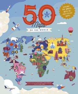
Geography, history, and culture spill from the pages in this luxuriously illustrated treasure trove of travel knowledge. Each two-page spread is dedicated to a different country, providing both quick-fire facts and the chance to delve deeper into what makes every nation unique.
Natural wonders, bustling metropolises, storied pasts, and cultural icons are all presented in expert detail by a pair of experienced explorers.
- Meet our earliest ancestors in Ethiopia, marvel at Machu Picchu in Peru, and visit the floating villages of Cambodia in this colorful guide to 50 fascinating countries.
- Each spread includes dozens of spotlighted locations, a timeline of the nation’s history, and introductions to the people who have helped shape it.
- With the expertise of Ben Handicott (Hello Atlas, Atlas of Adventures: Wonders of the World) and Kalya Ryan, alongside the stunning illustrations of Sol Linero (The 50 States, 50 Cities of the U.S.A.), experience the diversity of our world like never before.
50 Maps of the World reimagines what maps can be, providing not just a geographical fact fest but a vivid insight into the history, culture, and wildlife that shape our living world. It is the perfect gift for young globetrotters and armchair travelers alike.
The 50 States series of books for young explorers celebrates the USA and the wider world with key facts and fun activities about the people, history, and natural environments that make each location within them uniquely wonderful. Beautiful illustrations, maps, and infographics bring the places to colorful life.
Also available from the series: 50 Trailblazers of the 50 States, Only in America, Only in America Activity Book, Only in California, Only in Texas, We Are the United States, 50 Adventures in the 50 States, 50 Maps of the World Activity Book, and The 50 States.
Available Editions
| EDITION | Other Format |
| ISBN | 9781786036407 |
| PRICE | $30.00 (USD) |
| PAGES | 112 |
Average rating from 38 members
Featured Reviews
 Rebecca B, Educator
This book is brilliant. It looks at 50 countries around the world, once to a page. The illustrations are beautiful but what makes this book different is that there’s a nice little timeline for each country with annotated landmarks and well known people. Perfect for sparking a children’s interest and as a point for further study.
I’d highly recommend this book and will be ordering copies.
50 Maps of the World is an atlas of countries of the world presented with lots of trivia and timelines and highlights for each country represented. Due out 1st Sept 2020 from Quarto on their Wide Eyed Editions imprint, it's 112 pages and will be available in hardcover format.
This is a fun, information dense, graphically appealing (but very busy) atlas. Each of the maps shows an outline map of the country (or countries - Scandinavia is taken together, for example) in question, noteworthy cities, landmarks, cultural tidbits, and a timeline in a highlighted text box. There's another highlighted text box for each entry with key facts such as Capitals, languages, currency, two letter country codes, national birds and flowers, and populations. There are small cameo insets with notable figures from each country's history. The countries themselves are arranged geographically by continent, starting with Europe and ending with the Antipodes.
The authors have included a hunt & find activity search at the end of the book as well as a comprehensive index and an abbreviated glossary.
There's a lot to like here. I would recommend it for classroom/library use and it would also make a nice selection for home library or homeschool use. I'm not sure how long it'll remain current (as the author's state in their introduction, countries change continually), but it's a nice kid's atlas with appealing art. I was impressed that the authors managed to cover the 1994 Rwandan genocide in an age-appropriate manner.
Four stars.
Disclosure: I received an ARC at no cost from the author/publisher for review purposes.
Jeremy B, Reviewer
Very pretty book. Tempted to buy it for my 6-year-old. Hope he gets to travel the world someday. Thanks for giving me a chance to read — will recommend for sure.
Experienced explorers / authors, Ben Handicott and Kalya Ryan, alongside popular illustrator, Sol Linero, have created a book of wonder to delight readers time and time again! The book is like a rocking chair visit to 50 countries around the world. Join a fascinating journey to learn key facts and moments in history, meet important people, and check out culture, food, geography, plants and animals popular in different countries around the world. Readers will explore land structures, waterways, museums, plus more!
In the back of the book is a Search and Find pictorial scavenger hunt to retrace one's journey through the book. There is also a glossary of important words and a comprehensive index. Children can learn to use an index for retrieving interesting information about the world. Do you know what country features the Caves of Heaven and Hell? What is pho and where is the Dwingelrots? The index will help you find out!
With a fabulous overview of each country, readers may use this book as a steppingstone to learn more through other books, magazines, and websites. And someday, readers may want to travel to some of these countries – a spark of interest first begun through this book! Let’s get going …. Can you find the image of a pink beach and find out where is the Pink Beach? And where is the Painted Village of Zalipie?
Thank you Wide Eyed Editions for allowing me an early reading of a delightful book sure to please readers of all ages. Thank you NetGalley for providing an easy platform to access this digital review copy. (Review has been posted on GoodReads.)
Thank you to NetGalley and the publisher for an electronic copy to read and review.
This book will be fantastic in print! Electronically, it was difficult to fully read on my tablet.
Each page has a map of a region/country and little facts and information about that area. I love the little tidbits of info, and know that many kids will like to look and read through this book. I am looking forward to getting a copy for my classroom. It is a great way to get kids reading, especially when they have a keen interest in the world, but maybe not so keen interest in fiction or chapter books.
The search and find page, as well as the glossary at the end will also be so engaging for kiddos!
The book was Fantabulous!! The content and graphics and presentation was eye-popping! My 10 year old granddaughter happened to be visiting and she was sitting with me & I got her input on your book! She was enthralled and so enthusiastic that she was so disappointed when I told her that the book was unavailable until September!! She said well can’t you download your copy to my moms iPad! I told her that it was protected and she said but Grandma I need it to look up all these countries on the airplane! They live in Pennsylvania where I live in Texas!! The book truly is stunning and I learned quite a few new facts about some countries that I didn’t know!! I am definitely going to be purchasing this book for my granddaughter when it is available because she was bewitched by all the staggering amount of information, but it was how it was showcased that caught her interest! Plus the type of material & statistics that were featured is what garnered my attention! The book was presented in a fun, lively, easygoing way so that children and adults would both enjoy!!!
 Librarian 710080
Not your ordinary map, this book catches the eye with its colourful illustrations and information and fun facts for everyone. The world, countries and people have changed and shifted over time. This will give you quick references and key facts to inform and spark questions and conversation for minds young and old.
Reviewer 594011
I have a thing for atlases. Since I was a kid, I could spend hours at a time, poring over a good atlas, I find them fascinating.
The reason I'm not giving this one 5 stars is because, I find it too 'busy'. There is A LOT to look at on each page and it may actually be a little too engaging, to the point it becomes a bit overwhelming. I have to say, I'm really not a big fan of all the bits of text and portraits covering the entire shape of the country/countries.. The map/country gets lost in the overload of information.
A fun illustrated educational atlas of 50+ countries in the world. Basic geography, facts, and history are included for each country. This would be perfect for elementary school aged children.
Thank you NetGalley and the publisher for providing this ARC.
The author starts by explaining what a country is and how the countries that we know change over the course of history as new ones are formed and old ones dissolve. Having established this baseline, next comes the sense of what will be found in each colorful map spread. There will be history, people of note, key facts, bodies of water, historical sites, capital cities and more. Truly an adventure is being offered to young and inquisitive explorers in these fifty maps which include countries throughout the world, starting with France and other European countries and then traveling the continents.
I would have adored this book as a child. I also enjoy it now that I am an adult.
Many thanks to NetGalley and the publisher for this title in exchange for an honest review.
Hannah L, Reviewer
Fifty Maps of the World is a beautifully illustrated book full of interesting facts! Unfortunately, the book is a bit too crowded with facts; found it difficult to read because of this. It would be so much more enjoyable if some of the information was removed to make it easier on the eyes. I also found the layout to be confusing in some areas. This book is still wonderful despite it's flaws. Children will love the colors and illustrations, and will most definitely learn something new!
*3.5 Stars*
Educator 488420
Maps are political. Always. So we should start there. The things I didnt like about this were where I would’ve made different choices about who I showed, what facts I shared etc.
The format itself is awesome though and there is so much to appreciate about this. There are timelines, notable people, and facts places all over different locations. It’s a nice quick deep dive into a country. It’d be a fantastic resource for the classroom as long as it was explicitly (!!!) taught that maps are political and counter perspectives/ facts/ timelines were brought in depending on what country you zoomed in on. I would not have this be a sole resource but an excellent spring board.
The definition of country was really great at the beginning as well as the instructions for how to look for features of the book.
The range of countries is great (albeit of course there are a bunch left out since it only covers 50.. and a choice like doing Israel and then no Palestine is... a choice).
All in all I was super excited about this book, especially as I have seen firsthand how lacking geography instruction is for our kids in the US. This would be a great resource in a batch of resources.
Thanks to the publishers and Netgalley for an ARC in exchange for an honest review !
Jen F, Reviewer
We loooove maps in our family. Both my kids learned to iron on paper maps they wanted to frame. My son is a geography enthusiast who can name almost any pro league soccer stadium in the world. This book absolutely calls to us.
The book is laid out well with lots of information on slightly modified maps. It introduces people of note, moments to remember, and spotlights certain areas of each map.
There are so many things to love! Lots of women included in the people of note, so many interesting tidbits. We all have gained new places we want to go when the pandemic is over, like the lava fields of Yatta Plateau in Kenya, or Isla del Sol in Bolivia.
For younger audience members who might be having this read aloud to them there is a search and find legend at the back of the book. I can't imagine any child who isn't going to want to search for Poopoo Land. All of the illustrations are endearing.
We had a couple of issues with the book, however. One is that my kids have struggled with upper and lower case letters, since this doesn't exist in Japanese. Some of the fonts in this book are stylized to mix the upper and lower case letters, on the letters i and l among others, which can confuse beginning or ESL readers.
Another issue is that I noticed at least one inaccuracy. It says of Fukuoka Castle that "visitors come in droves to see the cherry blossoms from up high in the crumbling turret." In actuality the turret that is pictured is on one of the lower levels of the castle walls, and the cherry blossom views are from the ramparts. Also, nothing about the castle is crumbling, the walls are in amazing condition as well as the buildings that are still there. This is just a little thing, and understandable as I'm sure they couldn't have visited every place on these 50 maps, but it makes us wonder what else may be inaccurate in the book.
The good parts of this book will stick with us for a long time as we dream of traveling, so we give it 4 out of 5 dumplings.
Reviewer 691180
I got requested for Our Wonderful World by Ben Handicott, which I really liked. After I search for other similar book and found this, but I thought these are different book even the cover looked similar... But no, this is the same book, so I just copy the text which I wrote for that book.
I need this book! This book contains a beautifully drawn map of 50 countries with a lot of added information like landmarks, famous people or facts.
The truth is that I didn't read everything in this book. I started to read every little fact but after 10 pages I realized that I am not interested in every fact. After that, I just checked quickly evert country, which are the spotlights and if I was interested in that country, I read the information. In my view, this book needs to be on a shelf, and if I am interested in a country or planning a visit, just read thought the information.
My favourite part was the maps with the landmarks. I want to visit everything which was highlighted in this book.
The facts weren't boring, but I wasn't interested to read them. I really loved the idea of a book, full of beautifully illustrated maps. I will definitely buy it after the release.
Cathy P, Librarian
I always enjoy Flying Eye books, vibrant and informative and this one is just as nice. The maps obviously give only a selective amount of information but the snippets that have been included do give you a flavour of each country. and as such are a good introduction. I enjoyed looking at all the small details and the illustrations as ever are beautifully done. I think this would be a book to be enjoyed much like a picture book and as such it would have reasonably broad appeal.
I really loved this book and all of the information about each map. I learned so much just by reading through. It is a lot to read on each page, but it is 100% worth it to find out all the neat facts about Hungary, Poland, Turkey, Scandinavia, and so many more countries and regions! The illustrations really round it out and draw everything together; they're fun and bright, and well-thought out.
An amazing addition to everyone's home library and a great tool for geography teachers and enthusiast!
This illustrated edition fills your eyes with amazing and pretty accurate infographics of 50 countries of all 7 continents.
Each two-page spread provide a set of basic facts of each State, a general list of historical relevant events, a few notable people (both past and present) and pinpointed highly interesting landmarks and tourist attractions, all wrap up in a beautifully crafted visual composition that is a the delight to see and would probably entice both young and old.
Great for working inside and outside the classroom, a trip planning or just to enjoy learning about the world and it's wonders.
When reading, it's only downside seems to be the unfulfilled desire to have a spread for each and every country in the world!
Jo C, Reviewer
Thank you for sharing this book with me, #NetGalley !
Don't know when did maps start to fascinate me. But this one is like infographic maps, with a lot of new knowledge to absorbs. So very useful, mostly for kids to be able to position themselves in a country. And as updated as who is and where does Greta Thurnberg came from.
What a great way for any child to learn about planet Earth!
Includes 50 colorful and info-rich spreads on featured countries, including memorable sites, key facts, historical timelines, and influential people.
A perfect children’s gift to inspire lifetime travel!
5 of 5 Stars
Pub Date 01 Sep 2020
Thanks to Quarto Publishing Group-Wide Eyed Editions and NetGalley for the review copy. Opinions are mine.
#50MapsoftheWorld #NetGalley
Readers who liked this book also liked:


We Are Bookish
General Fiction (Adult), Romance, Women's Fiction

JUNO
Arts & Photography, Comics, Graphic Novels, Manga, Travel

We Are Bookish
General Fiction (Adult), Mystery & Thrillers
Jaclyn Moriarty
General Fiction (Adult), Sci Fi & Fantasy, Women's Fiction

Kate Westbury; Hank Phillippi Ryan; Vikki VanSickle; Mariah Fredericks; Rose Wilding; Sara Paretsky
Mystery & Thrillers
Ellie Alexander; M. C. Beaton; R.W. Green; Donna Andrews; Carolyn Haines; Mindy Quigley; P. J. Nelson
Mystery & Thrillers