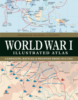
World War I Illustrated Atlas
by Professor Michael S Neiberg
This title was previously available on NetGalley and is now archived.
Send NetGalley books directly to your Kindle or Kindle app
1
To read on a Kindle or Kindle app, please add kindle@netgalley.com as an approved email address to receive files in your Amazon account. Click here for step-by-step instructions.
2
Also find your Kindle email address within your Amazon account, and enter it here.
Pub Date Oct 14 2023 | Archive Date Nov 03 2023
Amber Books Ltd | Amber Books
Talking about this book? Use #WorldWarIIllustratedAtlas #NetGalley. More hashtag tips!
Description
Available Editions
| EDITION | Other Format |
| ISBN | 9781838863548 |
| PRICE | £22.99 (GBP) |
| PAGES | 192 |
Links
Available on NetGalley
Average rating from 6 members
Featured Reviews
This book is amazing! I really enjoyed all the photographs and maps, and while I know the story of World War I. these maps will be a game changer. I definitely want to get a physical copy and use it in my classroom. I was especially interested in all of the U-Boat sinking sites. I saw the U-505 in Chicago a few years ago on a private tour, and I've seriously been obsessed since. WWI gets so overshadowed by WWII, but this I hope will bring back some much needed attention to the war that started it all!
 Willy M, Reviewer
Neiberg has given us a pretty good tool to look at the First World War. The World War I Illustrated Atlas is full of essential overviews and details in maps that give, sector by sector, month by month, in some cases, even day by day accounts of the conflict that ranged over the entire world and killed tens of millions.
Don't get me wrong, it isn't perfect. This is a book that cannot possibly include all of the details, but it's a great reference that will come in handy when doing research, or just trying to get a handle on what happened. WWI was a conflict that had masses of data as the mainspring of organization. For a war that had so much inept blunders by individuals that ended up killing masses of people, the war generated statistics that still today we are trying to get a handle on. This reference guide, does help, but nothing can ever be a complete reference on such a large subject.
I highly recommend this book.
 Reviewer 862825
Chair of War Studies in the Department of National Security and Strategy at the United States Army War College, Michael Neiberg’s <i>World War I Illustrated Atlas</i> presents a visually rich and easy to read history of World War I.
The book is divided into seven sections, starting with an overview of the conditions that led to war before shifting the focus to the Balkans, where the war began. From there Neiberg moves through the different theatres of war: the eastern and western fronts, the wider (global) war, sea and air, and concluding with the aftermath. For each of these there are brief written descriptions and a wealth of maps showing the entire combat eras and then focusing on specific geographic locations for the individual battles.
Each section begins with archival photos, as the emphasis here is on visual information. Neiberg condenses complicated multi phase battles and the changing strategies of the militaries into short descriptions to accompany the many maps. Keys are highly important for understanding the presented information, with the focus on military campaigns in the different theatres.
An excellent short work for those who know little of World War I looking to understanding the campaigns and battles year to year. For more focused exploration of specific battles or the individual experience, readers will need to look elsewhere.
Readers who liked this book also liked:

We Are Bookish
Historical Fiction, Literary Fiction, Multicultural Interest


We Are Bookish
General Fiction (Adult), New Adult, Romance


We Are Bookish
Multicultural Interest, OwnVoices, Teens & YA

Views expressed in promotions/advertisements do not necessarily reflect those of NetGalley or its affiliates.
© 2026 NetGalley LLC
• All Rights Reserved


Views expressed in promotions/advertisements do not necessarily reflect those of NetGalley or its affiliates.